
Hirakimata - summit to sea
by John Ogden
Hirakimata (Mount Hobson) is the highest point on Great Barrier Island, visible from almost anywhere on the island, and on a good day from Auckland. The mountain, buttressed on all sides by rugged volcanic terrain, rises from sea level to 627m, over less than 4km to the west coast and 5km to the east. This altitudinal change, over a relatively short distance, on Hauraki Gulfís outer-most island, has seen distinct ecosystems developófrom the summit to the sea.

Black petrel on the nest. Data indicates a slow decline for this species ó the birdís main breeding colony is on Hirakimataís summit.
For many people the walk to the summit of Hirakimata, and the splendid views of the island, Little Barrier, the Coromandel Peninsula, north to the Mokohinau and Hen and Chickens islands, and south to Cuvier are the highlights of a visit to Great Barrier. Thousands of visitors sign the book on the summit every summer, while others prolong the experience by spending a night in the splendid Department of Conservation hut on nearby Mount Heale.
The overnighters, if they know to look, will see Great Barrierís most iconic endangered bird, the black petrel (Taiko. They will surely hear the eerie staccato calls as the birds come in after dark to their nesting burrows in the summit forest. Theyíll probably see the smaller, paler Cookís petrels too, and on fine nights, long-tailed bats.

Kirk’s Pine
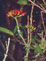
Metrosideros flowers
Forest zonation with altitude

Figure 1. Distribution of selected trees, shrubs, tree ferns and other species on transects from sea level to the summit of Hirakimata (627m). Black bars are species found only on Hirakimata or a few adjacent summits. Green bars are species found on all the main mountains of Great Barrier Island and usually at sea level too. Bars indicate presence only at that altitude, without reference to abundance.
* Kunzea sinclairii is the creeping kanuka, found only on Hirakimata.
The upper montane forest1 (Figure 1) that supports these birds is an ancient mix of conifers and broadleaf trees, found only in a few other places ñ mountain summits on infertile volcanic rocks ñ in Coromandel and Northland. This zone, from 400m above sea level (a.s.l.) to the summit, contains yellow silver pine, monaoa, Kirkís pine, and toatoa, mixed with the more familiar rimu, miro and kauri. Broadleaf trees include species more familiar from the South Islandís West Coast, such as tawheowheo, southern rata, tawairi and the rare creeping rata, Metrosideros parkinsonii. This forest type was commoner during a cooler, wetter period over 30,000 years ago ó it is a relic ecosystem, with species not seen elsewhere on Great Barrier.
This tall dense forest, surviving in the damp clouds which often hide it from view, passes abruptly into the lower structure of the montane forest zone below 400m. The sharp boundary was created by fires during European kauri-logging and would previously have been more gradual ñ indeed many species transgress it. More open vegetation is evident from 400 to 200m a.s.l., dominated by shrubby plants or small trees, though most of it was kauri forest once. A marked change occurs across this zone, with seven lowland plants being added and six upper montane species lost.
Three species found only on Great Barrier Island inhabit open rocky areas ñ creeping tea-tree (Kunzea sinclairii), Allomís daisy tree (Olearia allomii) and Rehuaís hebe (Hebe macrocarpa var. rehuarum).

Creeping tea-tree (Kunzea sinclairii) spreading over volcanic rocks on Hirakimata.
Hebe species (H. macrocarpa /pubescens var. rehuarum) Rehuaís hebe ñ is found only on Great Barrier Island.

Olearia Allomii (shrub daisy) is endemic to Great Barrier Island.
The lower forests, in the Kaiaraara valley for example are a diverse mix of about 20 tree species, often dominated by puriri, kohekohe and the two types of tawa (Beilschmeidia tawa, B. tawaroa) but with emergent conifers; kahikatea in the valleys, rimu on the slopes and kauri or totara on the ridges.
The montane forest of Hirakimata contains more native forest bird species than any other forest area on Great Barrier.
The coastal strip is dominated by pohutukawa and some coastal shrubs, although throughout Great Barrier much of the lowland zone has been cleared and now carries manuka or kanuka (under which are seedlings of future forest trees).
From the coast to the summit, a continuum can be seen, of ever-changing vegetation composition dependent on the altitudinal preferences of species, and their responses to past disturbances, especially fire.
Bird distribution with altitude
The vegetation pattern is reflected in other components of the ecosystem, such as the birds. The montane forest of Hirakimata contains more native forest bird species than any other forest area on Great Barrier (Figure 2). There are tomtits and now a few robins, two species which are not readily seen or heard elsewhere on the island. The robins have colonised since being re-introduced at Windy Hill and Glenfern sanctuaries, and may survive in this high altitude forest due to reduced predation by rats. Of course birds move between zones, so that while kakariki and long-tailed cuckoo are characteristic of the upper forest, they also occur at lower altitudes óindeed kakariki nest in the splendid remnant of lowland forest at Okiwi.
Hirakimataís ësatelliteí reserves
All around Hirakimata other native ecosystems of high conservation value are linked to the mountain through Maori tradition, and by their geology, hydrology and ecology. Visible from the summit ridge of Hirakimata are a series of ësatellite reservesí. To the north is remote Te Paparahi, the final refuge of kokako before the last pair were removed to Hauturu in 1996. Ngati Rehua Ngati Wai ki Aotea are planning to restore the area and return this iconic bird. This is a project which will require large-scale pest control.

Figure 2. Overall number of native bird species recorded (light grey); or combined (all species) density per hectare estimates (dark grey) for different locations2.
To the north-east of Hirakimata are the Whangapoua Estuary and Okiwi spit. The estuary contains a well-documented transition from mangroves, through saltmarsh to fresh-water ecosystems3. It is an essential feeding ground for New Zealand dotterel, pateke, variable oystercatcher and various migrant waders4. The area has great cultural significance and is still an important source of kaimoana. The enclosing dunes of Okiwi spit have the best native dune vegetation on the island, and contain evidence of past sea-level fluctuations, tsunami and Maori middens.
The Department of Conservation manages the Okiwi Basin to conserve pateke. Clearly visible from the beach are the cliffs of Rakitu, also a DoC reserve, mooted as the next big pest eradication project on the island.
Looking to the south east, the Kaitoke Swamp (Te Puea) is the largest area of semi-natural wetland in the Auckland region and is a ëSpecial Placeí in the islandís Conservation Management Strategy. It is probably the last refuge for the nationally endangered bittern5 on Great Barrier and the spotless crake, as well as pateke and banded rail. The largest population of fern birds6 can also be found here. Plant communities and the vegetation history of the swamp have been described in detail7 and include at least one orchid regarded as nationally critical (Prasophyllum hectorii).
The ecological value of the Kaitoke Swamp cannot be over-stated including as a significant freshwater reservoir7. Unfortunately, this ecosystem is being invaded by alien plants such as Mexican devil. Rats and feral pigs are also present.
Rugged bush-covered country lies to the south and west of Hirakimataís summit, with some remnant forest and much regenerating kauri in the Wairahi Reserve. Some of these kauri stands are infected with Phytophthora taxon Agathis (PTA), a soil-borne pathogen capable of killing mature and younger kauri trees. Steep streams in this hill country, such as the Kaiaraara, descend to flooded valleys with small areas of saltmarsh and mangroves.
Much of the coastline is still wild, and there are likely to be small colonies of fluttering shearwater and other birds on the rocky headlands. Forming a ëtwiní to Rakitu, Motu Kaikoura stands across the entrance to Port FitzRoy with Glenfern Sanctuary just to the north. Both these areas have well documented flora and fauna, and both are managed for conservation and outdoor education.
But Hirakimata is the central and most significant reserve on Aotea. The mountainís ecosystem is like no other, is surrounded by a network of accessible reserves linking the summit to the sea, including Okiwi Park and the spit, Whangapoua Estuary, Kaitoke wetland and Glenfern Sanctuary, mostly located close to the centre of Department of Conservationís activities ñ the new headquarters at Okiwi (Figure 3).

Figure 3: Map of part of Great Barrier Island, centred on Hirakimata. The black outline encloses most of the main ridge of Hirakimata and the main black petrel nesting colony. Blue circles indicate the ësatellite reservesí; starting at the top, moving clockwise: Te Paparahi, Whangapoua Estuary and Okiwi spit, Rakitu, Kaitoke wetland, Wairahi Forest Sanctuary, Motu Kaikoura, Glenfern Sanctuary, Kotuku Peninsula and Okiwi Park. The circles are not proportional to size but give an indication of location. The red square is the location of the new Department of Conservation headquarters.
Hirakimata is the central and most significant reserve on Aotea.
Awareness of the linkage and interactions between the terrestrial forest ecosystems and the health of the marine environment could be realistically promoted through what is already known from studies on Whangapoua Estuary and elsewhere8.
The reserve assets within and around Hirakimata should be promoted as places where visitors can experience the full range of the islandís biota, and the linkages between them should be made apparent.
But, these special places are managed in what seems like a piecemeal way ñ an inevitable consequence of the Department of Conservationís much reduced on-island capacity.
A plan to link the Hirakimata track system to the reserves around it, perhaps by additional tracks in broad corridors of vegetation would be a worthy priority for the new Aotea Conservation Park Advisory Committee.

From the summit to sea view west from Hirakimata to Port FitzRoy, Glenfern Sanctuary/Kotuku Peninsula and Motu Kaikoura, Little Barrier Island (Hauturu) in the distance.
Photo: E Waterhouse
Environmental News Issue 36 Winter 2016
________________________________________________________________________________________
Notes:
1ëMontaneí relates to mountains.
2Asher Cook. (2013) An investigation of the population size and distribution of tomtit and red-crowned parakeet on Mount Hobson/Hirakimata and the results of five minute bird counts at four different sites on Great Barrier Island. Report to GBIET, 2013.
3Deng et al. 2006. Application of palynology to describe vegetation succession in estuarine wetlands on Great Barrier Island, northern New Zealand. Journal of Vegetation Science 17: 765-782. Also: Deng, et al. 2006. Journal of Biogeography. 33: 592- 608. Also: Deng et al 2004. New Zealand Journal of Botany 42: 568-588. Also: Ogden et al. 2006. Sequential impacts of Polynesian and European settlement on the vegetation and environmental processes recorded in sediments at Whangapoua Estuary, Great Barrier Island, New Zealand. Regional Environmental Change 6: 25-40.
4Ogden (2016): In Great Barrier Island Environmental News 2016 # 35. Also: Ogden, J., & Dowding J. E. 2013. Population estimates and conservation of the New Zealand dotterel (Charadrius obscurus) on Great Barrier Island, New Zealand. Notornis 60: 210-223.
5Geary, A., Corin, S. & Ogden, J. 2012. Monitoring Report: Australasian Bittern; Great Barrier Island. Department of Conservation Report: GRBAO 22380.
6Anderson, S. H. & Ogden, J. (2003). The bird community of the Kaitoke wetland, Great Barrier Island. Notornis. 50(4): 201-209.
7Horrocks, M., Ogden, J., Nichol, S.L., Alloway, B.V., Sutton, D.G. (2000) Palynology, sedimentology and environmental significance of Holocene swamps at northern Kaitoke, Great Barrier Island, New Zealand. Journal of the Royal Society of New Zealand. 30: 27 - 47. Also: Pegman, A. P. McK. & Ogden, J. (2005). Productivity-decomposition dynamics of Typha orientalis at Kaitoke Swamp, Great Barrier Island, New Zealand. New Zealand Journal of Botany 43: 779-289; Also: New Zealand Journal of Botany 44: 261-271. Also: Rutherford, G. N. (1998). The current vegetation of Kaitoke Swamp, Great Barrier Island (Aotea). Msc. Thesis, University of Auckland.
8Ogden, J. et al. (2006). Sequential impacts of Polynesian and European settlement on vegetation and environmental processes recorded in sediments at Whangapoua Estuary, Great Barrier Island, New Zealand. Regional Environmental Change 6 : 25-40.